
Sunday 22 September 2013
Swim 56: Kingston Bridge to Teddington Obelisk - The End
So this is it. The last stage of the odyssey down the length of the Non Tidal Thames. It's a short swim, so take your time and enjoy it. Float and bob. And make sure you celebrate properly at the end!
We met near Teddington Lock where there is plenty of roadside parking:
http://goo.gl/maps/TqNZi
You could then shuttle up to the start point but there is very limited parking there, so we chose to walk:
http://goo.gl/maps/Mt3vC
Jump in at the same place you got out last time and then swim down to the lock. Hop out at the lock, over the bridge, and get back in on the other side of the island for the last stretch down to the Obelisk.
http://goo.gl/maps/3kdBW
If you arrive at low tide there's a lovely beach where you can take photos and open the champers!
Total Distance: 250.97 km
Distance from Cricklade: 230.6 km
Distance Driven: 5031.5km
And next? Well it's still 111 km to the start of the North Sea at Sea Reach Number 1 Buoy!!!

Sunday 1 September 2013
Swim 55: Molesey Lock to Kingston Bridge
We met at Lower Ham Road where there is a very limited amount of on street parking - so make sure you get there early:
http://goo.gl/maps/rJZiA
We shuttled up to the free car park at Sadlers Ride, Hurst Park, Molesey:
http://goo.gl/maps/ezV7i
We then walked down to the lock and jumped in:
http://goo.gl/maps/RxrHr
And swam down to the finish point about 1km past Kingston Bridge. The exit point was a set of steps leading down to the shore. There are several sets of stairs so you would be wise to scout out the exit point before setting off to the shuttle parking.
http://goo.gl/maps/Fllfe

Monday 19 August 2013
A Swim #4 catch-up
Raf, Neil and Sharon did a catch-up of Swim #4 on 19th August 2013. This isn't so much a trip report, as a round-up of useful information for those yet to catch up this (or earlier) swims.
We can add that the Riverside Car Park in Lechlade had a charge of £2 for all-day parking, for this you get a car park attendant, and an ice-cream van if you're lucky.
We can also add that the road to Hannington Bridge is closed, due to works strengthening the bridge itself. These works are due to go on until 19th October 2013, and status updates can be found on the Roadworks Closures and Diversions page for Swindon. Fortunately we approached from the north, so could still park near the layby just to the north of the bridge.
Instead, after wandering around for a while near the bridge trying to find a good spot, we ended up going via the south bank of the river, on the upstream side of the bridge. We entered a field with a gate and an anglers' sign, hopped over a (non-barbed) wire fence and descended down the neat turf-cut steps that the workers on the bridge had made, right next to the bridge itself. Careful, the big stones in the riverbed near the bridge are slippy!
The flow was a little more than in the Lower Thames the previous two days (no rain fell overnight), but not much more. You could definitely tell which way the current was going, but most of the way, the assistance it offered was small.
Despite the length, it was a really lovely swim. The river twists and turns and there's always something new to look at round every corner.
On 19th August 2013, the Environment Agency's reading was 2.02m, at the lower end of the typical range for this section of the river. Where they take their measurements from, I don't know, but 2.02m was not the depth of the water as we stood in it next to the bridge that day; a better description would be "calf-deep". However, for relative comparison of river levels, the recorded measurements seem useful: last year, when I did Swim #3, the water levels at Hannington Bridge were about 1.5m deeper, as were the Environment Agency's measurements.
Anyway, the water depth varied a lot, but gradually got deeper over the whole swim. For the first half of the swim, the water level was always deep enough to float in, but not always deep enough to swim in; depending on your arm length and swimming stroke, your knuckles or knees might graze the bottom. There were also a lot of weeds and reeds, which we either carefully circumnavigated or ignored and swam over the top of, and there are a small number of hidden branches with pointy ends to watch out for in the water.
The middle third was much more conducive to swimming, with several patches where you couldn't wade because the water was too deep. Much to our surprise, approx half-way along we found 4 boats moored, and some others in a little side-area where the river turns sharply north. Once you see the boats, the depth remains deeper than your toes can touch, and you can pretty much put your head down and swim swim swim all the way to Lechlade.
Oh, and we did see a couple of anglers, right at the end of the swim. Not one of which accused us of ruining the river.
Access and Parking
We followed the same logistical arrangements for Swim #4 as the original Swim #4 in June 2011, because as mentioned in the report for the original Swim #4, the Thames path doesn't go anywhere near the river (on the plus side, no anglers!), so it requires car shuttling.We can add that the Riverside Car Park in Lechlade had a charge of £2 for all-day parking, for this you get a car park attendant, and an ice-cream van if you're lucky.
We can also add that the road to Hannington Bridge is closed, due to works strengthening the bridge itself. These works are due to go on until 19th October 2013, and status updates can be found on the Roadworks Closures and Diversions page for Swindon. Fortunately we approached from the north, so could still park near the layby just to the north of the bridge.
Refreshments
Aside from the ice-cream van in the car park, there are no refreshments anywhere. Having read the original Swim #4 report, we opted to take refreshments with us in our big orange Chillswim drybags. This worked well, apart from one thing: there aren't many good getting-out spots on the swim, and the one we did use, approx 4km along, had a very very soft muddy exit, so our hands were all caked in mud by the time we scrambled up onto the bank. We could have done with some wet wipes in our drybags. Or napkins. Or anything more effective than dry clumps of grass, really.Getting in
Tricky. I recall getting out from Swim #3 at a tree just past the bridge; the tree was there alright, but we could find no sign of the awkward little-used path to get back to the road! There is a shelving access point on the north bank just upstream of the bridge, but that has rather a lot of nettles guarding it.Instead, after wandering around for a while near the bridge trying to find a good spot, we ended up going via the south bank of the river, on the upstream side of the bridge. We entered a field with a gate and an anglers' sign, hopped over a (non-barbed) wire fence and descended down the neat turf-cut steps that the workers on the bridge had made, right next to the bridge itself. Careful, the big stones in the riverbed near the bridge are slippy!
River Conditions
It was approximately 18 °C, with occasional warm and cool patches. Make sure you're not going to under/overheat in your chosen swimming attire: this is a long swim, with not many getting-out points, and there's no path alongside the river.The flow was a little more than in the Lower Thames the previous two days (no rain fell overnight), but not much more. You could definitely tell which way the current was going, but most of the way, the assistance it offered was small.
Swim Length
Raf's satellite gadget reported 6km (just under 4 miles), which differs in opinion from Chris', reporting 3.6 miles. Still, rather a long swim, whichever way you look at it.Despite the length, it was a really lovely swim. The river twists and turns and there's always something new to look at round every corner.
Water Levels
The water levels here can vary significantly, from "a wet walk" to "too deep to touch the bottom". If you check out the current water level readings at Hannington Bridge (Environment Agency), that together with the following should give you an idea how swimmable you are likely to find this stretch of river.On 19th August 2013, the Environment Agency's reading was 2.02m, at the lower end of the typical range for this section of the river. Where they take their measurements from, I don't know, but 2.02m was not the depth of the water as we stood in it next to the bridge that day; a better description would be "calf-deep". However, for relative comparison of river levels, the recorded measurements seem useful: last year, when I did Swim #3, the water levels at Hannington Bridge were about 1.5m deeper, as were the Environment Agency's measurements.
Anyway, the water depth varied a lot, but gradually got deeper over the whole swim. For the first half of the swim, the water level was always deep enough to float in, but not always deep enough to swim in; depending on your arm length and swimming stroke, your knuckles or knees might graze the bottom. There were also a lot of weeds and reeds, which we either carefully circumnavigated or ignored and swam over the top of, and there are a small number of hidden branches with pointy ends to watch out for in the water.
The middle third was much more conducive to swimming, with several patches where you couldn't wade because the water was too deep. Much to our surprise, approx half-way along we found 4 boats moored, and some others in a little side-area where the river turns sharply north. Once you see the boats, the depth remains deeper than your toes can touch, and you can pretty much put your head down and swim swim swim all the way to Lechlade.
Swans
This was a good time of year to do this swim, with regards to swans. The cygnets were fully swan-sized but still grey, and we didn't get any swan aggro. Having said that, we didn't see many swans. One group (1 parent, 4 cygnets) passed us during our refreshment break in hot pursuit of any bread that might be carried by the family in the flat-bottomed boat zooming upstream. Another group (2 parents, 2 cygnets) went on ahead and then preened themselves in a muddy patch to the side whilst we glided past.Other Wildlife
We saw a couple of herons, one small-ish bird that looked like it might have been a juvenile little grebe, and lots of swallows near Inglesham.Oh, and we did see a couple of anglers, right at the end of the swim. Not one of which accused us of ruining the river.
Sunday 18 August 2013
Swim 54: Sunbury Lock to Molesey Lock
We met in the car park (Free parking) in Sadlers Ride, Hurst Park, Molesey:
http://goo.gl/maps/7f5Ua
Got changed and shuttled up to the start at Sunbury Lock and parked in the Elmbridge Xcel Leisure Complex Walton on Thames KT12 2JG:
http://goo.gl/maps/ZRcz4
Jumped in at Sunbury Lock
http://goo.gl/maps/Ssz7T
and swum down to Molesey lock, passing to the right of all islands. Although we normally swim on the left, on this stretch we swum on the right to keep away from the inhabited islands.
http://goo.gl/maps/Z8bGv
On arrival at Molesy lock we walked back along the tow path to the car park and shuttled shuttle drivers back to the their cars at the Leisure centre.
This is swim #72 from Michael Worthington's 'I ♥ the Thames' and is about 4.75km

Saturday 17 August 2013
Swim 53: Desborough Island to Sunbury Lock
We met in the car park (Free parking) at the Elmbridge Xcel Leisure Complex Walton on Thames KT12 2JG:
http://goo.gl/maps/5qLl2
Got changed and shuttled up to the start at Shepperton, trying not to disrupt any weddings upon arrival:
http://goo.gl/maps/nkvoF
Swam round the rest of Desborough Island, turned left and joined the main channel, and exited at Sunbury Lock, on the right avoiding the weir that runs parallel to the river:
http://goo.gl/maps/nae2w
(You may have to exit early to avoid the lock cut but can judge that on the day, depending on traffic.)
This is mostly swim #71 from Michael Worthington's 'I ♥ the Thames' and is about 5km or half a Dart. We started part way down the swim but went the 'proper' way around Desborough Island so it was longer than the route in the book. No short cuts for us!
And walked back to the Leisure centre, not far from the weir, at the start of the lock cut.

Saturday 3 August 2013

Swim 52: Chertsey Meads to Desborough Island
We met here:
http://goo.gl/maps/yGoai
This is the free Chertsey Meads car park that we used at the end of swim #51. We then shuttled 2 or 3 cars containing our dry eating togs down to a small free car park at the finish.
http://goo.gl/maps/Xzixo
Then we swam the 2.5 km to Shepperton Lock which was a good place to meet bank support for cakes. After the lock the river gave us options but we stuck to our left and took the scenic M shaped route going north of Desborough Island. The finish point is a slipway on the top of the first part of the M about 1km from the lock:
http://goo.gl/maps/uArPu
Sunday 21 July 2013

Swim 51: Staines Penton Hook Lock to Chertsey Meads
We met at the first car park at Chertsey Meads:
http://goo.gl/maps/JL41i
We then walked up to the start at Staines Penton Lock (you can either swim across or cross at Chertsey bridge):
http://goo.gl/maps/6NAsI
And then swam back to a small beach near the car park:
http://goo.gl/maps/a29Ox
Simples. This is swim 69 in Michael Worthington's 'I ♥ the Thames'' and is about 3.5k
Saturday 20 July 2013

Swim 50: Runnymede Bell Weir Lock to Staines Penton Hook Lock
We met here, in the Runnymede Pleasure grounds car park:
http://goo.gl/maps/wiFQp
(Parking is £4.50 / 3 hours or £6.00 all day.)
We shuttled a couple of cars down to a small car park at Egham Hythe, near the finish but on the wrong side of the river. (But you can swim across, right?) here:
http://goo.gl/maps/vTVqn
(Small car park but free.)
We got changed, strolled down to Bell Weir Lock:
http://goo.gl/maps/uGiAH
We jumped in and swam down to Penton Hook Lock,
http://goo.gl/maps/cm1L2
stopping for Elevenses on the way down. This is swim 68 in Michael Worthington's 'I ♥ the Thames'' and is about 4.5k.
Sunday 7 July 2013

Swim 49: Old Windsor Lock to Runnymede Bell Weir Lock
We meet again, same as Swim #48, on the single track Ham Lane, just as it crosses the river a short way upstream of the finish at Old Windsor Lock:
http://goo.gl/maps/pBCkP
You can park on the verge at the edge of the road.
We got changed, walked the sort distance down stream to Old Windsor Lock:
http://goo.gl/maps/1VYdZ
jumped in and swam down to Bell Weir Lock (taking care to keep to the right on the approach to avoid the weir):
http://goo.gl/maps/cDURO
from where we had a magnificent view of the M25 in all it's 14 lanes of glory. This is swim 67 in Michael Worthington's 'I ♥ the Thames' and is about 4.5km. You can optionally shuttle some cars down to the Runnymede Pleasure Ground car park here, near the finish or walk back:
http://goo.gl/maps/aLsuK (£4.50 / 3 hours or £6.00 all day.)
And then we headed off for lunch at the Jolly Gardners - highly recommended:
http://www.jollygardeners.com/
Saturday 6 July 2013

Swim 48: Romney Lock to Old Windsor Lock
We met on the single track Ham Lane, just as it crosses the river a short way upstream of the finish at Old Windsor Lock:
http://goo.gl/maps/8GAia
You can park on the verge at the edge of the road.
We got changed and walked up to Romney Lock, crossing the Albert and Victoria bridges, with a brief excursion into Datchet along the way.
We jumped into the backwater at Romney Lock where one of the fishing platforms allowed for easy access to the water:
http://goo.gl/maps/Tb7kF
and swam down to just before the weir at Old Windsor Lock. You can't swim in the lock cut and the weir is dangerous so we got out at a convenient spot just short:
http://goo.gl/maps/HtJLt
This is swim 66 in Michael Worthington's 'I ♥ the Thames' and is about 4.8k.
Sunday 2 June 2013

Swim 47: Boveney Lock to Romney Lock
We met at the same car park as the last swim:
http://goo.gl/maps/lF00L
Remember that the car park is locked at 5pm. We then walked down to the entry point at Boveney Lock:
http://goo.gl/maps/XUjvt
We then swam down to the exit point at Romney Lock.
http://goo.gl/maps/udga3
Be aware that you are not allowed to swim in the lock cut. After the swim we walked back to the start. You can make the walk shorter by cutting the corner at Eton.
Caution:
We encountered a significant amount of large boat traffic in this section. Make sure you are visible and that you tell the lock keepers.
Sunday 12 May 2013
Swim 46: Monkey Island to Boveney Lock
On Sunday 12th May 2013, about a dozen of us met up at 10.30am in a car park close to Boveney Lock. Meanwhile, Sharon had some catching up to do from Bray Lock, a little upstream of Monkey Island, so had already got in the river earlier, at 10.15am:

Sharon, leaving Bray Lock
Originally we were going to shuttle up to near Monkey Island by car, but due to limited parking spaces, it would have been a complicated shuttle run, so instead, we decided to walk up to the getting-in place. Part-way there we found Sharon swimming downstream:

Sharon says hello to Lesley, Adam and Charles (photographer) on the towpath.
Earlier, Sharon saw assorted birdlife, including some terns wheeling about the river like giant grey-white swallows, and an indifferent Great-crested Grebe.
We ended up getting in at 11.45. The temperature wasn't too bad today at 12.3°C, but was not as warm as last Monday, when some of us had had a swim in the Thames at 14.5°C!

Temperature taken at Bray Lock, 10.10am
The getting-in place we used was just upstream of the footbridge over to Monkey Island, on the towpath/Thames path side of the river.

Getting in. From left to right: Jeremy, Rafael and Paul

Getting in. From left to right: Chris, Hywel, Claire, Lesley
The swim took a while.

Swimmers, viewed from the towpath
There were a lot of people on the river, and we got many friendly greetings from people on the boats ("Isn't it cold?" "YES!"), and the occasional cheeky comment from the ubiquitous young lads on the rowing boats. Watch out for the green buoy just after the sharp bend: whilst it does provide a shallow area to stand up and stretch legs, there are a lot of hidden logs and branches. Some of us got a bit scratched.
A little after the green buoy, we were very glad to see our bank supporters Charles and Natasha, along with Sharon (finished, dried and changed already!) standing on a wooden raft at the side of the river, with refreshments.

The view from the rafts, awaiting the swimmers in the distance.
Some of us felt that choc-cherry brownies were more urgent than getting fully out of the water:

Claire refuelling.

Paul trying not to drip on the brownie.
After some chocolate krispies and flapjacks too, we got back in to do the last few hundred metres to the lock. Chris found that the edge of the raft wasn't too sound, and slipped a bit, so the rest of us decided to jump in instead. Some of us leapt in with gusto;

Rafael outdoes his usual poses for photographs.
most of us made a big splash;

Sharon watches the splash that Adam made.
...and some of us were graceful, leaving a little splash:

Jeremy watches Chloe's no-splash splash.
After reaching the lock, Paul was going to get out, then changed his mind once he spotted the photo opportunity of the flagpole on the opposite bank.

Paul and his flagpole.
After finishing, we walked back the short distance from the lock, changed, and went to The Pineapple pub at Dorney, where they serve a huge selection of (very tasty) sandwiches, as well as soup, chips, and roast dinners. Thanks for booking the table, Jeremy!

Hywel put a candle from the mantelpiece onto our table, for that romantic effect.

Swim 46 - Monkey Island to Boveney Lock
We met at the finish in a free car park near to Boveney (note that the car park is locked at 5pm):
http://goo.gl/maps/Mmx33
We walked up to the start, but you could shuttle to the same small car park as at the last swim:
http://goo.gl/maps/UZOJO
Then we entered water here where there is a nice beach:
http://goo.gl/maps/qAcwT
We then swam down to Boveney Lock, a distance of 4km:
http://goo.gl/maps/qzTEf
and returned to finish car park where we met up. Check out the church of St Mary Magdalene once used by the river folk on your way back from the lock to the car park.
This swim brings you up to Windsor Race Course.
We ate at The Pineapple at Dorney which has an extensive selection of sandwiches.
Sunday 28 April 2013

Swim 45 - Boulters Lock to Monkey Island
We met at Boulters Lock car park as at the last swim (£1 for all day):
http://goo.gl/maps/AjnSh
Parking near the end of the swim is difficult but you can try the small car park in the grounds of Bray Lake if you can get access:
http://goo.gl/maps/235VD
Or you can park at the private car park a few kilometres downstream where we based ourselves for the next two swims:
http://goo.gl/maps/KAD87
Be careful to note what time both of these car parks are locked!
We got into the water at Boulters Lock:
http://goo.gl/maps/u3tnU
and swam on to Bray lock, keeping to the left on the approach.
Caution:
Beware of rowing boats from Maidenhead Rowing Club between Boulters and Bray locks.
We then continued on to a small beach just short of the footbridge just past Monkey Island. The beach is hard to see from upstream so keep close to the left bank and you should see it almost level with the downstream tip of the island.
http://goo.gl/maps/1Iir3
We crossed over the footbridge to the shuttle car park to change before heading back to Maidenhead to have lunch at Boulters Restaurant with Terrace Bar.
http://www.boultersrestaurant.co.uk/boulters-terrace-bar/menus/
Sunday 14 April 2013
Year 2 - Radley to Maidenhead
Swim 44 brings to a conclusion the second year of the Thames Swim. Year three will see us at the end of the non tidal section:
Total distance travelled: 195.37 km
Distance travelled since Cricklade: 175.00 km
Distance remaining to Teddington Lock: 51.6 km
Distance remaining to Sea Reach No1 Buoy: 161.19 km

Total distance travelled: 195.37 km
Distance travelled since Cricklade: 175.00 km
Distance remaining to Teddington Lock: 51.6 km
Distance remaining to Sea Reach No1 Buoy: 161.19 km


Swim 44 - Cookham Lock to Boulters Lock
We met in the car park near Boulters lock (only £1 for the day):
http://goo.gl/maps/W9MbH
We then shuttled up to Cookham and parked near the lock access:
http://goo.gl/maps/BuZ7X
We had a brisk walk to Cookham lock across Odney Common and entered the water here at Cookham lock:
http://goo.gl/maps/gpqFY
Maybe we swim for approximately 3.3km and got out at Boulters lock:
http://goo.gl/maps/MwTaz
Caution:
Stay close to the RIGHT as you get towards the lock as the current is very strong towards the weir.
We then had lunch at Boulters Restaurant with Terrace Bar.
http://www.boultersrestaurant.co.uk/boulters-terrace-bar/menus/
Swim 44: Cookham to Boulter's Lock
More than a dozen of us met at 10.30am at the car park near Boulter's Lock, on Sunday 14th April 2013. There is a 1.9m bar on the car park there so poor Bertie was banished to what parking could be found elsewhere.
There was some discussion of how cold the Thames would be, and we weren't sure whether the temperatures listed by Maidenhead Rowing Club were accurate - 6°C throughout the whole of March? Then a sudden leap up to 9°C two days ago? Really? But when Charles took the temperature,...

The water temperature at the lock: 8.9°C
...we had to eat our words. 9°C it was. This was certainly warmer than the river has been lately, but still firmly in the category of FLIPPIN' COLD. The sun, however, smiled on us and the air temperature hovered around 17-18°C, positively tropical!
We shuttled up to Cookham, and walked over the common towards the lock. At this point, Angela (one of our fabulous bank support duo) noticed that the Thames path deviates somewhat from the lock here, and she started back to Cookham itself to rejoin the Thames path and get a headstart on the swimmers. Meanwhile, our other fabulous bank supporter, Charles, walked over with us to the lock and busied himself taking pictures of the 15 swimmers getting in.
Ready to get in: note Lindsay in his spiderman costume.
We got in just after 11.30am:

Neil gets in. Meanwhile, Claire is still posing for the camera.
No, this isn't Susan, despite the neoprene abundance, yellow hat and orange float, it's actually Lesley:

Lesley plays with her new inflatable toy.
Below we have Carol starting the swim:

Carol starting to swim from the lock.
Well it might be Carol. Difficult to tell really, many of us were difficult to identify, what with the goggles and all the neoprene we had on!!
Sharon was the only one not wearing a wetsuit. Sparkling in the sunlight, the river looked too tempting and she decided that it had to be tried. Determined not to shriek too much as the cold water met skin, she started down the ladder, got to thigh-level, and then stood there gasping for a bit, hoping to get the gasp reflex mostly out of the way before getting in the water.

Sharon starts off, just near the lock.
Our beloved leaders, Sef and Jeremy, were last to get in:

Sef and Jeremy, leaving the lock.
A few metres down from the lock, we rejoined the main Thames stream, where the current was very "Wahey!" and "Wheeeeeeeeeeeeee!"

The start of the swim. Susan is in the foreground, leaving the lock,
with Carol, Chloe and Rafael further off, about to reach the current.
The current made the whole swim very fast, leaving us scarcely any time to look at the pretty cottage in the Cliveden grounds that featured in the Profumo scandal of a few decades ago.
However the river wasn't so fast that it deprived us of the opportunity to be asked "Isn't it cold?" by bank-dwellers, several times. Jeremy's reply: "Warmer than last time!"
Other things noticed during the swim included a kingfisher, which Susan spotted as a little turquoise arrow making for the safety of the swimmer-free zone.
Sharon found some trolls. Well, they were under a bridge! Underneath the bridge over a little slipway were two adult and two child trolls. Sharon waved and shouted "Hello trolls!!!!!" They waved back and shouted "Hello!"
The brisk upstream wind and even brisker downstream current combined to provide a fair bit of chop for us to contend with, and there were even waves in several places, despite very little passing boat traffic. But even the chop and waves didn't prevent all the swimmers from being ahead of both bank supporters.
Even with Angela's walking headstart, she only arrived at an easy wade-out getting out spot (a little over half-way, on the right, just past the long thin island in the middle of the river) after Sharon got out there, but soon enough to offer refreshments and a hot drink. Combined with the warm sun beating down, circulation was soon restored to fingers and toes that had started to get a bit numb.
Meanwhile, the rest of the swimmers were approaching the lock, keeping to the right bank to avoid weirs on the left. Near the lock, however, the current that had provided so much assistance earlier suddenly got the huff and abandoned us, making it very hard work to swim up the lock cut.
Charles had had a very brisk walk and only caught up with us all at the lock, just after the last swimmer got out at 12:30pm. Having managed not to take any photos of the middle of the swim, he instead photographed us standing around and guzzling delicious post-swim nosh.

Chatting and munching at the lock. The air was too warm for us to feel much urgency to change.
The gastronomically-inclined may be interested to know that the (delicious!) home-made fare included Sef's special hot spiced apple drink, Sharon's orange choc chip cookies, and Jeremy's florentines. Yes, Jeremy. No, not Mrs. Wellingham. Jeremy. Jeremy would like full credit for the florentines he stayed up until midnight making, thankyouverymuch!
Afterwards we went back to the carpark to change, and then most of us walked over to Jenner's cafe (a few hundred metres down the road from the lock) for lunch in the warm sunshine.

The daffodils were in full bloom near Boulter's Lock.
Saturday 16 March 2013
Swim 43 - Cock Marsh to Cookham Lock
This was the last of the Thames winter swims which also marked our entry to the Lower Thames. This swim is the last part of Swim 61 from Michael Worthington's I ♥ the Thames and is 1.4km long. Only another 14 to go to Teddington and the end of the non tidal Thames.
We me at the National Trust The Pound car park at Cookham (that's its name - parking is free!), here:
http://goo.gl/maps/rOO0S (Same place as the last swim)
A brisk walk to the edge of the National Trust Cock Marsh (that's its name, so I'll use it if want to) and we slid into the river at the tree where we exited last time, here or hereabouts:
http://goo.gl/maps/xljdp
We then swam down towards Cookham Lock.
CAUTION - IMPORTANT NAVIGATION NOTE:
Go under the bridge at Cookham using the 2nd arch from the right. There is a choice of three visible channels - take the middle narrow one that leads to the lock. The other two lead to weirs. (There is also a fourth channel to the far right but that will not be immediately apparent - you don't want to go down that one either.) It is recommend that you check this out for yourself before the swim from footpath over Cookham bridge.
We swam down the long lock cut - around 0.6km without the current assist we had become used to over the winter, where we exited at the lock, here:
http://goo.gl/maps/Z99Mf
We had lunch at The Ferry at Cookham bridge: www.theferry.co.uk

Sunday 17 February 2013
Swim 42: Bourne End towards Cookham
In the final official winter swim of the season before the balmy waters of March warm us next time we had another short swim. We met at the car park just outside Cookham here:
http://goo.gl/maps/ZLPZB
Be aware that the car park can be muddy and is popular with dog walkers so can fill up early.
We then walked across the field and up to the start at the railway bridge at Bourne End:
http://goo.gl/maps/GG9Ih
before being swept rapidly down towards our exit point by the brisk winter waters:
http://goo.gl/maps/pgGa0
Note that the tree by the exit point has now been savagely pruned. The little beaches that can be seen nearby have been shored up and no longer offer easy exit but the roots of the tree are a convenient stepping stone out.
After changing we indulged in ice creams (!!) and lunch at The Ferry in Cookham.

Sunday 20 January 2013
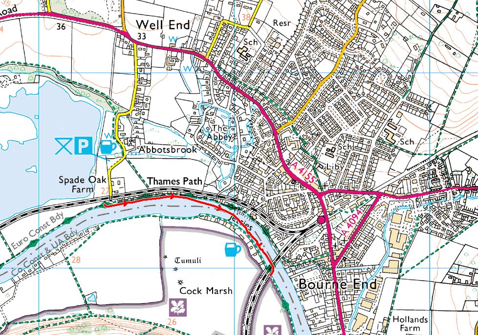
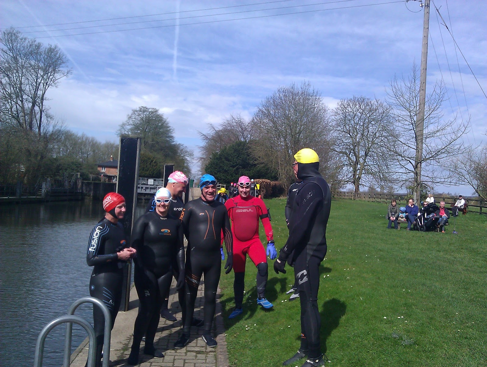
Swim 41: Spade oak to Bourne end. 20th jan 2013.
After a long gap since our last outing, we met at Bourne end railway station car park on a snowy January day. Wasn't sure how many folk would risk the roads, but pleasantly surprised to be greeted by a throng of Thames friends.

Although A few hardy types among us had recently swum in cold water events, wetsuits were definitely the order of the day.

We gingerly creep in and let the current work its magic.

And away we go.

The swans were not impressed, but we outnumbered them.

One of us was taking no chances with the cold.


A little over a kilometer away, we clamber out. Look we are still smiling.

A round of applause?, or frozen fingers.

An opportunity to make snow angels doesn't present itself often.

Ending in a fit of giggles. Yes, life is good.

And a colourful re entry back to Bourne end before a much deserved warm up and lunch at the pub.

Subscribe to:
Posts (Atom)