Sunday, 20 January 2013

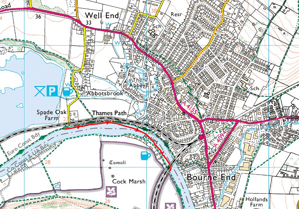
Swim 41: Spade oak to Bourne end. 20th jan 2013.
After a long gap since our last outing, we met at Bourne end railway station car park on a snowy January day. Wasn't sure how many folk would risk the roads, but pleasantly surprised to be greeted by a throng of Thames friends.

Although A few hardy types among us had recently swum in cold water events, wetsuits were definitely the order of the day.

We gingerly creep in and let the current work its magic.

And away we go.

The swans were not impressed, but we outnumbered them.

One of us was taking no chances with the cold.


A little over a kilometer away, we clamber out. Look we are still smiling.

A round of applause?, or frozen fingers.

An opportunity to make snow angels doesn't present itself often.

Ending in a fit of giggles. Yes, life is good.

And a colourful re entry back to Bourne end before a much deserved warm up and lunch at the pub.

Swim 41: Spade Oak to Bourne End
Originally scheduled for December, this swim was postponed to January due to flood conditions. Another winter swim (actually swum in the snow), this is approximately 1km and can be combined with the previous or next swims in warmer weather. It is part of Swim 60 from I ♥ The Thames.
We met at the car park at Bourne End station:
http://goo.gl/maps/fdkPO
This is the closest parking to the end of the swim but bring change for the meter or be prepared to pay by phone. Alternatively, you could meet at the Spade Oak car park as per the previous two swims:
http://goo.gl/maps/4Vvvu
We then walked back to the start point at Spade Oak:
http://goo.gl/maps/juRmS
and swam down to the exit point just beyond the rail bridge:
http://goo.gl/maps/7wd47
We met at the car park at Bourne End station:
http://goo.gl/maps/fdkPO
This is the closest parking to the end of the swim but bring change for the meter or be prepared to pay by phone. Alternatively, you could meet at the Spade Oak car park as per the previous two swims:
http://goo.gl/maps/4Vvvu
We then walked back to the start point at Spade Oak:
http://goo.gl/maps/juRmS
and swam down to the exit point just beyond the rail bridge:
http://goo.gl/maps/7wd47
Sunday, 18 November 2012


Swim 40: Downstream from Marlow to Spade Oak (Bourne End)
Once again a shorter winter swim that could be combined with the previous swim in warmer months. This swim is approximately 1.75km.
We met at the Spade Oak car park here:
http://goo.gl/maps/ZzI0C
Note, this is the free public car park not the pub car park which you will pass on the way.
We then walked upstream to the entry point at the small beach just downstream from the start of the island:
http://goo.gl/maps/GzNqz
before swimming back to the exit point just by the rail crossing leading back to the car park:
http://goo.gl/maps/tWG7U
We met at the Spade Oak car park here:
http://goo.gl/maps/ZzI0C
Note, this is the free public car park not the pub car park which you will pass on the way.
We then walked upstream to the entry point at the small beach just downstream from the start of the island:
http://goo.gl/maps/GzNqz
before swimming back to the exit point just by the rail crossing leading back to the car park:
http://goo.gl/maps/tWG7U
Subscribe to:
Posts (Atom)